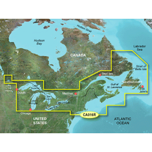
Garmin Bluechart G2 - HCA016R - Canada East G2 - Data Card
Manufacturer Part Number: 010-C1016-10
UPC #: 753759095765
Category: Garmin BlueChart g2 US
See your vessel's precise, on-chart position in relation to navaids, coastal features, anchorages, obstructions, waterways, restricted areas and more with this detailed marine mapping data.
Coverage:
- Provides detailed coverage of the North American east Coast from Nain, NL to Raritan Bay, NY featuring Newfoundland, Ile d'Anticosti, New York Harbor
- Full U.S. and Canadian coverage of the Great Lakes in their entirety
Features:
- Shaded depth contours, coastlines, spot soundings, navaids, port plans, wrecks, obstructions, intertidal zones, restricted areas and IALA symbols
- Seamless transitions between zoom levels and more continuity across chart boundaries
- Standard 2-D direct overhead or 3-D "over the bow" map perspective for easy chart reading and orientation
- Safety Shading* enables contour shading for all depth contours shallower than your defined safe depths
- Fishing Charts* to scope out bottom contours and depth soundings with less visual clutter on the display
- Plan and organize routes from your computer with HomePort™ (sold separately)
*Only available on compatible devices


![Garmin GC14 Marine Camera [010-02667-00]](http://cemarine.com/cdn/shop/products/89457XL_512x512.jpg?v=1623183122)
![Garmin GC 100 Wireless Camera [010-01865-30]](http://cemarine.com/cdn/shop/products/72576XL_512x512.jpg?v=1576634181)
![Garmin Panoptix PS22-TR LiveV Forward Down Transducer [010-01945-00]](http://cemarine.com/cdn/shop/products/66839XL_512x512.jpg?v=1576632624)
![Garmin GPSMAP 8624 Chartplotter GN+ [010-01512-50]](http://cemarine.com/cdn/shop/files/97072XL_512x512.jpg?v=1733440163)
![Garmin LiveScope Plus Ice House System [020-00332-00]](http://cemarine.com/cdn/shop/files/99860XL_512x512.jpg?v=1728496811)