
Click or scroll to zoom
Tap or pinch to zoom
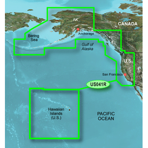
Garmin Bluechart G2 - HUS041R - Us West G2 - Data Card
by Garmin
Call for Availabity!
$160.70
$134.99
SKU 35808
Manufacturer Part Number: 010-C1015-10
UPC #: 753759095802
Category: Garmin BlueChart g2 US
Manufacturer Part Number: 010-C1015-10
UPC #: 753759095802
Category: Garmin BlueChart g2 US
Provides detailed coverage of the North American west coast from the North Slope of Alaska to the U.S. - Mexican border including the Hawaiian Islands. Coverage features the Aleutian and Channel Islands, the Inside and Outside Passages, Puget Sound, San Francisco Bay, and San Diego Bay. Detailed coverage also includes the Columbia R. to its juntion with the Snake R., and the Snake R. to Lewiston, ID.
Features
Features
- Includes realistic navigation features showing everything from shaded depth contours and coastlines to spot soundings, navaids, port plans, wrecks, obstructions, intertidal zones, restricted areas, IALA symbols and more.
- Features smooth displays, including seamless transitions between zoom levels and more continuity across chart boundaries.
- Allows users to choose between standard 2-D direct overhead or 3-D "over the bow" map perspective to make chart reading and orientation easier.
- Provides Safety Shading (in compatible units), allowing mariners to enable contour shading for all depth contours shallower than user-defined safe depths.
- Provides Fishing Charts (in compatible units), allowing mariners to scope out bottom contours and depth soundings with less visual clutter on the display.
- Allows users to conveniently plan and organize routes, from your computer, before your trip with HomePortT, compatible trip-planning software (sold separately).
![Garmin GC14 Marine Camera [010-02667-00]](http://cemarine.com/cdn/shop/products/89457XL_512x512.jpg?v=1623183122)
![Garmin GC 100 Wireless Camera [010-01865-30]](http://cemarine.com/cdn/shop/products/72576XL_512x512.jpg?v=1576634181)
![Garmin Panoptix PS22-TR LiveV Forward Down Transducer [010-01945-00]](http://cemarine.com/cdn/shop/products/66839XL_512x512.jpg?v=1576632624)
![Garmin LiveScope Plus Ice House System [020-00332-00]](http://cemarine.com/cdn/shop/files/99860XL_512x512.jpg?v=1728496811)
![Garmin ECHOMAP UHD2 93SV LiveScope Plus Ice Fishing Bundle LI w/ECHOMAP UHD2 93sv, LiveScope Plus System Lithium-ion Battery [010-02688-35]](http://cemarine.com/cdn/shop/files/99859XL_512x512.jpg?v=1728496804)