
Click or scroll to zoom
Tap or pinch to zoom
Garmin Topo US 24K Southeast MicroSD/SD
by Garmin
Call for Availabity!
$99.99
$89.99
SKU 39070
Manufacturer Part Number: 010-C0959-00
UPC #: 753759081751
Category: Garmin Topographical microSD
Manufacturer Part Number: 010-C0959-00
UPC #: 753759081751
Category: Garmin Topographical microSD
TOPO U.S. 24K contains built-in DEM (digital elevation model) data which supports 3-D terrain shading and route elevation profiles in compatible units to help estimate terrain difficulty. With routable roads and trails in metropolitan and rural areas, getting to your destination is made simple by creating point-to-point routes on compatible units. Plus, you'll get turn-by-turn directions on compatible units, and you can search for points of interest by name or proximity to your location. TOPO U.S 24K contains descriptive topographic detail including dense elevation contours and enhanced shoreline detail to help prepare you for your next backpacking, hiking or camping adventure.
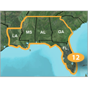
Southeast Covers: Detailed 24K topographic coverage of Louisiana, Mississippi, Alabama, Georgia and Florida.
Preprogrammed microSD/SD card unit compatibility:
Use with Oregon series, Colorado series, GPSMAP 78, 78s or 78sc navigators to access the full feature set of TOPO U.S. 24K, including full 3-D view and terrain shading. Standard compatibility with the following units: Dakota 20, Edge 705, 605, eTrex x-series, Rino x-series, Astro 220, GPSMAP 60CSx, 60Cx, 76CSx, 76Cx, 620, zumo series, nuvi 500 series.
TOPO U.S. 24K Special Features include:
- Routable road content and searchable business points of interest provided by NAVTEQ
- Routable dirt road and trails including metropolitan and rural areas
- Searchable points of interest including food and drink, lodging, parks, trails, camping, fuel and more.
- Dense contour interval generated from elevation data approximating the
24K USGS quad maps
- Enhanced shoreline equivalent to 24K
- Built in DEM and 3-D terrain shading on compatible units (Also available
on your computer using the DVD.)
- Elevation profile of routes and tracks on compatible units helps you
estimate terrain difficulty (Also available on your computer using the DVD.)
- Detailed lakes, rivers and streams, plus geographic place names such as
summits, trailheads, towns and natural features
- National, state and local parks, forests, recreational and wildlife area
boundaries
- Create point-to-point routes on compatible units
- Bureau of Land Management township, range and section information
- USGS quad names and information available when reviewing a location
- BaseCamp software for managing data on GPS and computer (only on DVD)
![Garmin GC14 Marine Camera [010-02667-00]](http://cemarine.com/cdn/shop/products/89457XL_512x512.jpg?v=1623183122)
![Garmin GC 100 Wireless Camera [010-01865-30]](http://cemarine.com/cdn/shop/products/72576XL_512x512.jpg?v=1576634181)
![Garmin Panoptix PS22-TR LiveV Forward Down Transducer [010-01945-00]](http://cemarine.com/cdn/shop/products/66839XL_512x512.jpg?v=1576632624)
![Garmin Autopilot Check Valve Kit [010-11203-10]](http://cemarine.com/cdn/shop/files/102888XL_512x512.jpg?v=1714598246)
![Garmin Class B Compact v2 Drive Unit [010-12029-01]](http://cemarine.com/cdn/shop/files/103387XL_512x512.jpg?v=1711571379)