
Click or scroll to zoom
Tap or pinch to zoom
Garmin GPSMAP® 546S Chartplotter/Fishfinder Combo w/o Transducer
by Garmin
Call for Availabity!
$789.99
$758.39
SKU 36365
Manufacturer Part Number: 010-00774-02
UPC #: 753759096175
Category: GPS - Fishfinder Combos
Manufacturer Part Number: 010-00774-02
UPC #: 753759096175
Category: GPS - Fishfinder Combos
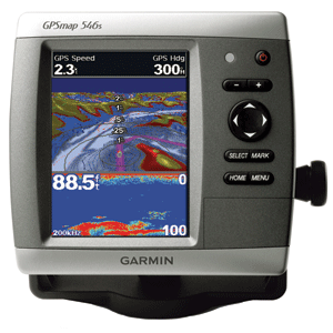
GPSMAP 546S Chartplotter/Fishfinder Combo Without Transducer
The GPSMAP 546S is a compact chartplotter/fishfinder combo that features a high-resolution, super-bright 5" VGA color display along with an improved high-speed digital design for increased map drawing and panning speeds. It's ready to go with an easy-to-use interface and a built-in, satellite-enhanced basemap preloaded with all U.S. coastal areas, including Alaska and Hawaii as well as detailed charts for Bermuda. The GPSMAP 546 also accepts BlueChartr g2 Vision cards for added features and functionality such as high-resolution satellite imagery, 3D views and Auto Guidance technology.
Explore The Seas
The GPSMAP 546 comes ready to go with preloaded U.S. coastal area map data. For areas outside the U.S., the GPSMAP 546 has a worldwide basemap with satellite images in place of more traditional maps. The GPSMAP 546 also comes standard with a high-sensitivity GPS receiver for superior satellite tracking and quicker acquisition times. In addition, the GPSMAP 546 can receive U.S. graphical weather data via optional GXM 51 satellite receiver/antenna. And with an SD card slot, it's easy to add additional maps without connecting to a computer.
Add Sonar
Where applicable, the sounder version, GPSMAP 546s, comes with a powerful dual-frequency transducer that clearly illustrates depth contours, fish targets and structures whether you're fishing in freshwater or off the coast. The GPSMAP 546 and GPSMAP 546s are also NMEA 2000-certified for easy connectivity with sensors, instruments and future marine offerings.
Add Extras With BlueChart g2 Vision
With the optional BlueChart g2 Vision SD card, you can add a whole dimension of exceptional features to your chartplotter.
- 3D Mariner's and Fish Eye view provides you with a 3-dimensional perspective of map information, both above and below the waterline
- High-resolution satellite images and aerial photographs help you orient yourself in unfamiliar areas
- Auto Guidance technology searches through all relevant charts to create a route you can actually follow - one that avoids obstacles, shallow water, buoys and other obstructions
![Garmin GC14 Marine Camera [010-02667-00]](http://cemarine.com/cdn/shop/products/89457XL_512x512.jpg?v=1623183122)
![Garmin GC 100 Wireless Camera [010-01865-30]](http://cemarine.com/cdn/shop/products/72576XL_512x512.jpg?v=1576634181)
![Garmin Panoptix PS22-TR LiveV Forward Down Transducer [010-01945-00]](http://cemarine.com/cdn/shop/products/66839XL_512x512.jpg?v=1576632624)
![Garmin Autopilot Check Valve Kit [010-11203-10]](http://cemarine.com/cdn/shop/files/102888XL_512x512.jpg?v=1714598246)
![Garmin Class B Compact v2 Drive Unit [010-12029-01]](http://cemarine.com/cdn/shop/files/103387XL_512x512.jpg?v=1711571379)