
Click or scroll to zoom
Tap or pinch to zoom
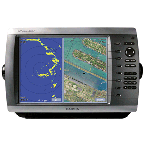
Garmin GPSMAP® 4012
by Garmin
Call for Availabity!
$2,399.99
$2,303.99
SKU 28907
Manufacturer Part Number: 010-00592-00
UPC #: 753759066055
Category: Network Capable Displays
Manufacturer Part Number: 010-00592-00
UPC #: 753759066055
Category: Network Capable Displays
GPSMAP® 4012
Garmin International is pleased to announce the GPSMAP 4012. The power of networking meets the brilliance of great design in the new 4000-series chartplotters from Garmin. These big, bright multifunction displays (MFDs) combine video-quality resolution and luminous colour with the latest in sensor and data options to serve as your all-in-one "nerve centers" for the Garmin Marine Network.
Both MFDs offer worldwide satellite imagery and a new simplified user interface. The GPSMAP 4012 features a 12.1" XGA "big screen" display and alphanumeric keypad.
Plug in optional BlueChart® g2 Vision cards to add true 3D-view detailed mapping capabilities (both above and below the waterline), plus helpful auto guidance, high-resolution photomapping detail, and "real picture" aerial photos of ports, harbors, marinas, waterways, navigation landmarks and other points of interest.
Product Features and Specifications
Enable the full functionality of the GPSMAP 4000-series with the addition of a BlueChart g2 Vision SD card
BlueChart g2 Vision cards provide:
Standard Configuration
GPSMAP 4012, bail mount and knobs, GPS 17 (flush mount or use included pole mount adapter), protective front cover, power cable assembly, video cable assembly, flush mount hardware, in-line fuse kit for GPS 17, marine grommet kit, crimp connectors, owner's manual and quick reference guide
Garmin International is pleased to announce the GPSMAP 4012. The power of networking meets the brilliance of great design in the new 4000-series chartplotters from Garmin. These big, bright multifunction displays (MFDs) combine video-quality resolution and luminous colour with the latest in sensor and data options to serve as your all-in-one "nerve centers" for the Garmin Marine Network.
Both MFDs offer worldwide satellite imagery and a new simplified user interface. The GPSMAP 4012 features a 12.1" XGA "big screen" display and alphanumeric keypad.
Plug in optional BlueChart® g2 Vision cards to add true 3D-view detailed mapping capabilities (both above and below the waterline), plus helpful auto guidance, high-resolution photomapping detail, and "real picture" aerial photos of ports, harbors, marinas, waterways, navigation landmarks and other points of interest.
Product Features and Specifications
- Includes WAAS-enabled, 12 parallel channel GPS sensor with 30 ft. cable length
- Display: GPSMAP 4012 12.1-inch, 4096 colour capable XGA sunlight readable display (1024 x 768 pixels) 1400 nits of brightness
- New streamlined user interface offers easy selection of functions and features
- Preloaded worldwide satellite imagery
- Fresh new design that has a "flat panel" look when flush mounted
- Single SD memory card slot for BlueChart g2 Vision cards, as well as saving waypoints, routes and tracks to a SD card which can be shared with others
- Backlit keypad for easier operation at night
- Alphanumeric keypad for easy data entry (GPSMAP 4012 only)
- Auto-dimming display
- Three built-in network ports for connection to a Garmin radar, GSD 22 sounder, or another MFD
- Compatible with all Garmin Marine Network peripherals
- Two video inputs for onboard cameras supports PAL & NTSC video signals
- 1 XGA (4012) PC monitor video output
- Four NMEA 0183 inputs and two NMEA 0183 outputs supports both AIS and DSC
- Supports NMEA 2000
- Unit dimensions: GPSMAP 4012 14.8"W x 9.5"H x 4.6"D
- Alarms for anchor drag, arrival, off-course, proximity waypoint, clock, low battery voltage and GPS accuracy
- Waterproof: IPX7 submersible
- Power down backup of settings: customer settings are not lost when the unit is turned off
Enable the full functionality of the GPSMAP 4000-series with the addition of a BlueChart g2 Vision SD card
BlueChart g2 Vision cards provide:
- High-resolution satellite imagery when overlaid on the chart, will provide the mariner with unparalleled situational awareness
- Aerial reference photography provides "real world" photos of ports, harbors, marinas, waterways, navigation landmarks and other points of interest, offering the mariner another powerful tool for navigating unfamiliar waters
- Mariners Eye view Provides the mariner with a 3-D perspective of chart information for a quick, reliable and easy position fix.
- Fish Eye view 3D perspective below the water line for displaying bottom contours based on bathymetric charting data
- Auto guidance technology will search the attributes of all relevant charts to suggest the best course for navigation
- Fishing charts, tides, currents, marine services, coastal roads and points of interest detail
Standard Configuration
GPSMAP 4012, bail mount and knobs, GPS 17 (flush mount or use included pole mount adapter), protective front cover, power cable assembly, video cable assembly, flush mount hardware, in-line fuse kit for GPS 17, marine grommet kit, crimp connectors, owner's manual and quick reference guide
![Garmin GC14 Marine Camera [010-02667-00]](http://cemarine.com/cdn/shop/products/89457XL_512x512.jpg?v=1623183122)
![Garmin GC 100 Wireless Camera [010-01865-30]](http://cemarine.com/cdn/shop/products/72576XL_512x512.jpg?v=1576634181)
![Garmin Panoptix PS22-TR LiveV Forward Down Transducer [010-01945-00]](http://cemarine.com/cdn/shop/products/66839XL_512x512.jpg?v=1576632624)
![Garmin GPSMAP 723xsv Combo GPS/Fishfinder w/GMR 18HD+ Radar [010-02365-50]](http://cemarine.com/cdn/shop/files/103864XL_512x512.jpg?v=1714793032)
![Garmin Autopilot Check Valve Kit [010-11203-10]](http://cemarine.com/cdn/shop/files/102888XL_512x512.jpg?v=1714598246)