
Click or scroll to zoom
Tap or pinch to zoom
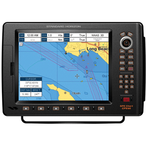
Standard Horizon CP590 12" GPS Chartplotter w/Coastal Charts
Call for Availabity!
$2,999.98
$1,673.39
SKU 40777
Manufacturer Part Number: CP590
UPC #: 788026126040
Category: GPS - Chartplotters
Manufacturer Part Number: CP590
UPC #: 788026126040
Category: GPS - Chartplotters
CP590 - WAAS GPS Chart Plotter External Antenna with built-in C-Map Cartography
Find every destination in style with the CP590 WAAS enabled GPS Chart Plotter. Preloaded with detailed maps for coastal navigation of USA including Alaska, Hawaii and Great Lakes, Canada, Bahamas, Caribbean, Cuba, Mexico, Puerto Rico, and Central America. Providing up to 10-foot accuracy the CP590 is designed to navigate you quickly and accurately to your destination. The CP590 boasts a crisp high-definition 12-inch 800x600 (SVGA) sunlight viewable TFT display. The 5 user programmable hot keys allow quick and easy access to a number of preprogrammed navigation displays. Connect your CP590 to two video sources and watch your favorite DVD, play your favorite video game, or monitor your engine room in full screen or Picture in Picture. In addition, the CP590 has one VGA Video output that connects to an external TV or Monitor allowing your passengers to view the vessels progress to a favorite destination. The CP590 is supplied with both a mounting bracket and flush mount hardware. NMEA connections are available to compatible Standard Horizon VHF for DSC distress and position polling functions. To find fish, wrecks and record water temperature, simply connect the optional FF525 50/200 kHz black box fish finder and transducer. Dedicated MARK, ROUTE and INFO keys allow for fumble free operation. In addition, the CP590 displays and tracks AIS (Automatic Identification System) targets when connected to an optional AIS Receiver. The CP590 is backed by an industry leading 3-year waterproof warranty.
Features:
- Preloaded with detailed maps for coastal navigation of USA including Alaska, Hawaii and Great Lakes, Canada, Bahamas, Caribbean, Cuba, Mexico, Puerto Rico, and Central American.
- 12" full VGA 800x600 high resolution display
- Supplied with external 50 channel WAAS GPS antenna
- C-MAP NT+ and C-MAP MAX compatible
- Radar / Fish Finder and AIS capable
- Able to show Distress and Position report calls received from a DSC VHF radio
- 2 NTSC or PAL video inputs with Picture In Picture
- VGA video output connects to an external monitor or compatible TV
- Alpha numeric keypad, and 6 programmable soft keys
- Customizable data windows
- Able to show Distress and Position report calls received from a DSC VHF radio
- GPS Status, Chart, Navigation, Highway, Celestial, Tides, Chart/Fish, Radar and AIS pages
- 3000 Marks / 50 Routes
- 20 Tracks with 10000 available track points
- C-MAP NT+ and C-MAP MAX compatible
- Dedicated MARK, ROUTE and INFO keys
- Dual chart window with independent zoom levels
- Satellite images on base map
- Font size selection on chart page
- Navigation and Route line thickness
- Navigate to an Olympic route
- Navigate a route in simulation
- Find Key, allows quick access to Port information, tide stations, wrecks, Point Of Interest and coordinates
- Automatic switching of Daylight savings time
- Route checking
- Supplied mounting bracket and flush mounting hardware
- 4 NMEA inputs / 5 outputs
- 3 Year Waterproof Warranty
![Standard Horizon CLIP-22 Belt Clip f/HX210, 300, 400, 400IS 890 [CLIP-22]](http://cemarine.com/cdn/shop/products/84344XL_512x512.jpg?v=1586940631)
![Standard Horizon Charge Cradle f/HX380 [CD-48]](http://cemarine.com/cdn/shop/products/80844XL_512x512.jpg?v=1571249006)
![Standard Horizon GX2410GPS 25W VHF w/GPS, AIS, N2K Hailer [GX2410GPS]](http://cemarine.com/cdn/shop/files/105679XL_512x512.jpg?v=1726773118)
![Standard Horizon HX891BT Handheld VHF w/Bluetooth - Navy Blue [HX891BTNB]](http://cemarine.com/cdn/shop/files/103609XL_512x512.jpg?v=1717565291)
![Standard Horizon HX891BT Handheld VHF w/Bluetooth - Black [HX891BTBK]](http://cemarine.com/cdn/shop/files/103608XL_512x512.jpg?v=1717565284)