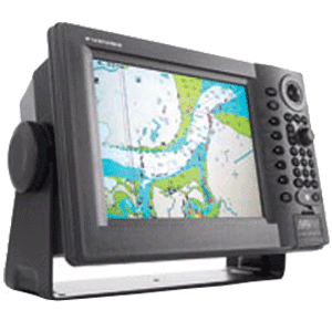
Furuno NavNet GP1920C/NT vx2 Chartplotter C-Map NT
Manufacturer Part Number: GP1920C/NT
UPC #: 611679288912
Category: GPS - Chartplotters
NavNet vx2 combines radar, GPS/WAAS chart plotter, fish finder, and network weather facsimile into an all-round navigation network. Its wide range of options fulfils virtually every desire you may have for navigation system.
Radar, GPS, Network fish finder, Network weather facsimile - a multistation integrated navigation network, NavNet vx2 lets you build your navigation system according to your needs. Utilizing state-of-the-art network technology, NavNet vx2 provides you with seamless data sharing and vast future expandability.
The heart of NavNet vx2 is its Ethernet-based network. Up to four displays, together with various navigational sensors, can be interconnected in addition to new MaxSea-NavNet navigational software, which adds even more features to your NavNet vx2 network. Stress-free navigation can be performed from any display unit connected to the onboard network, due to the high-speed transfer of data available.
- All display units are capable of controlling any component connected to the NavNet network
- Perfect for single or multi display installations
- Fully supports C-Map NT MAX charts.
- Utilizes SD cards for chart and memory.
- Fast chart drawing speed.
- Straightforward Plug n Play installation with wizard style set-up.
- AR-coated, high-brightness display unit for improved sunlight viewability.
Chart Plotter Features:
- Sunlight Viewable VGA (480 x 640) Display
- Front loading Mini-Chart Card port
- Fully compatible with C-Map NT MAX charts
- Simplified installation with new Network Wizard set-up
- Cursor L/L Position Display **
- On-Screen Display of Vessel Position, Heading, etc. *
- Vessel Position Display in L/L or Loran-C TD's
- North-Up, Course-Up or Automatic Course-Up display modes
- Plotter, Nav Data, Steering Director or Highway display modes
- Up to 8,000 points for ship's track and marks, 999 waypoints, 35 quick points, 1 MOB, 200 planned routes (max. 35 waypoints/route) and 1 quick route
- Add Multiple Displays by Connecting to NavNet Interface
- Add Network Sounder by Connecting to NavNet Interface
- MOB Key Stroke stores Vessel position and time
- Plotter Range Scales from 0.14 to 6,144 nautical miles
- 16 different mark symbols may be used
- Waypoint entry by L/L position or TD position or target Range and Bearing
- Plotter position interval may be set by Time or Distance Traveled
- TLL position from specific Furuno Radars or Echo sounders
- Full Functioning Infrared Remote Control
GPS Features
- Integral parallel tracking GPS/WAAS receiver
- Up to 900 knot tracking velocity
- 20 seconds for first position fix
- GPS position accuracy of approximately 10 meters, 95% of the time with S/A off
- WAAS position accuracy of approximately 3 meters, 95% of the time with S/A off
Power Requirements:
- 12 or 24 VDC


![Lowrance Elite FS 9 Chartplotter/Fishfinder - No Transducer [000-15707-001]](http://cemarine.com/cdn/shop/products/86350XL_512x512.jpg?v=1607095990)
![Lowrance Point-1 GPS/Heading Antenna [000-11047-002]](http://cemarine.com/cdn/shop/products/88826XL_512x512.jpg?v=1618010107)
![Faria Chesapeake Black 2" Depth Sounder w/Thru-Hull Transducer [13795]](http://cemarine.com/cdn/shop/products/74672XL_512x512.jpg?v=1576634654)
![Lowrance Gimbal Bracket Knobs [000-10467-001]](http://cemarine.com/cdn/shop/products/70697XL_512x512.jpg?v=1576633711)
![Humminbird Piranhamax 4 DI [410160-1]](http://cemarine.com/cdn/shop/products/62900XL_512x512.jpg?v=1576631747)