
Click or scroll to zoom
Tap or pinch to zoom
Garmin TOPO U.S. 24K Retail Card
by Garmin
Call for Availabity!
$99.99
$89.99
SKU 41982
Manufacturer Part Number: 010-11739-00
UPC #: 753759977139
Category: Garmin Software
Manufacturer Part Number: 010-11739-00
UPC #: 753759977139
Category: Garmin Software
TOPO U.S. 24K Retail Card
Part #: 010-11739-00
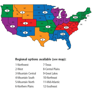
The TOPO U.S. 24K Retail Card is Garmin's popular 24K topo mapping product. Because the card gives consumers access to the most up-to-date maps on the Garmin website, dealers will be assured that they are always selling the most current mapping data available. Retailers can now choose to stock one single part number and offer their customers the flexibility to choose their own 24K region. This easy to redeem card is purchased from the dealer's retail store and allows users to download one of the 12 regions Garmin offers for the contiguous United States.
Want to make your trek through the mountains look like a walk in the park? TOPO U.S. 24K will guide you there with incredible detail. TOPO U.S. 24K provides a wide array of topographic information from terrain contours, elevations and summits to detailed coverage of lakes, rivers and streams. It also features a searchable database that includes urban and rural points of interest, and has routable roads and trails in metropolitan and rural areas to make getting to your destination simple by creating point-to-point routes on compatible units. You can even search for USGS quad names or for sections, townships and ranges where coverage applies.
Features:
Use With The Following Compatible Units:
Part #: 010-11739-00
The TOPO U.S. 24K Retail Card is Garmin's popular 24K topo mapping product. Because the card gives consumers access to the most up-to-date maps on the Garmin website, dealers will be assured that they are always selling the most current mapping data available. Retailers can now choose to stock one single part number and offer their customers the flexibility to choose their own 24K region. This easy to redeem card is purchased from the dealer's retail store and allows users to download one of the 12 regions Garmin offers for the contiguous United States.
Want to make your trek through the mountains look like a walk in the park? TOPO U.S. 24K will guide you there with incredible detail. TOPO U.S. 24K provides a wide array of topographic information from terrain contours, elevations and summits to detailed coverage of lakes, rivers and streams. It also features a searchable database that includes urban and rural points of interest, and has routable roads and trails in metropolitan and rural areas to make getting to your destination simple by creating point-to-point routes on compatible units. You can even search for USGS quad names or for sections, townships and ranges where coverage applies.
Features:
- Elevation profile of routes and 3-D shading on compatible units, so you can estimate terrain difficulty
- Coverage includes national, state and local parks, and forests and boundaries for both recreational and wildlife areas
- Searchable points of interest including restaurants, retail outlets, lodging, trails, camping, gas stations, outfitters and more
- Routable road content and searchable business points of interest provided by NAVTEQ
- Routable dirt roads and trails including metropolitan and rural areas
- Dense contour interval generated from elevation data approximating the 24K USGS quad maps
- Enhanced shoreline equivalent to 24K
- Built in DEM and 3-D terrain shading on compatible units
- Detailed lakes, rivers and streams, plus geographic place names such as summits, trailheads, towns and natural features
- Create point-to-point routes on compatible units
- USGS quad names and information available when reviewing a location
Use With The Following Compatible Units:
- Dakota 20
- Montana series
- Edge series
- Oregon series
- Colorado series
- GPSMAP 60 x-series
- GPSMAP 62 series
- GPSMAP 70 x-series
- eTrex x-series
- eTrex 20/30
- Rino 530HCx
- Rino 520HCx
- Rino 6xx series
- nuvi 500 series
- Astro
![C-MAP MAX NA-M320 -Passamaquoddy Bay ME-NC: Bathy - C-Card [NA-M320C-CARD]](http://cemarine.com/cdn/shop/files/33236XL_512x512.jpg?v=1731455787)
![Garmin Navionics+ NSEU643L - Mediterranean Black Sea - Marine Chart [010-C1272-20]](http://cemarine.com/cdn/shop/files/96083XL_512x512.jpg?v=1721858642)
![Navionics Platinum+ NPUS013R - Canada, West Alaska [010-C1467-40]](http://cemarine.com/cdn/shop/files/102656XL_512x512.jpg?v=1708636877)
![Navionics Platinum+ NPUS012R - Canada, East Great Lakes [010-C1466-40]](http://cemarine.com/cdn/shop/files/102655XL_512x512.jpg?v=1708636871)
![Navionics NAUS013R - Canada, West Alaska - Navionics+ [010-C1467-30]](http://cemarine.com/cdn/shop/files/102654XL_512x512.jpg?v=1708636864)