
Click or scroll to zoom
Tap or pinch to zoom
Garmin Homeport Marine Planning Software MicroSD/SD
by Garmin
Call for Availabity!
$29.99
SKU 37320
Manufacturer Part Number: 010-11423-00
UPC #: 753759099008
Category: Garmin Software
Manufacturer Part Number: 010-11423-00
UPC #: 753759099008
Category: Garmin Software
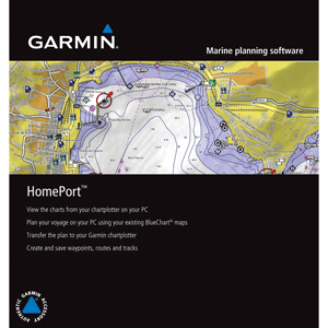
Marine Planning Software - HomePort
This new marine planning software is a must-have tool for mariners heading out on the open water. HomePort enables the use of existing BlueChart data from your preloaded chartplotter or preprogrammed card to help plot a course on your PC. You can then transfer this planned route back to your chartplotter and head out on your adventure. In addition to managing waypoints, routes and tracks, the HomePort application will also help predict fuel usage, tides, depth profiles, and more. It can plot a course to avoid hidden underwater hazards and keep your vessel away from shallow or rocky shorelines. You can easily create point-to-point routes, determine distance and bearing measurements between checkpoints, and calculate your estimated travel time for each leg of the journey.
After the HomePort application has been installed on your PC, this 2 GB microSD/SD card can also be used to transfer the preloaded BlueChart maps from your chartplotter to your PC for use with HomePort.
Compatible units: GPSMAPr 400 series, GPSMAP 500 series, GPSMAP 600 series, GPSMAP 3000 series (trip planning only), GPSMAP 4000 series, GPSMAP 5000 series, GPSMAP 640 chartplotters preloaded with BlueChart mapping.
Compatible maps: BlueChart g2 Vision, BlueChart g2 and BlueChart (both microSD/SD and Garmin data card formats).
System requirements: Windows XP SP2 or Windows Vista or Windows 7, 2.0 GHz Pentium 4 or equivalent, 250 MB disk space, 1 GB RAM, 1024 x 768 display, video card that supports DirectX 9.0, microSD/SD card reader, USB port.
Special Features Include:
- Displays both fishing charts and navigational charts from BlueChart g2 Vision
- Allows user to measure distance and bearing on the charts
- Displays gridlines for longitude/latitude
- Displays route/track depth profile
- Converts tracks into point-to-point routes and specifies speed for each leg of the route
- Provides ETA and arrival times for each leg
- Calculates fuel consumption
- Displays celestial information such as sunrise, sunset and moon phase
- Displays photos and point of interest detail
- Supports vector charts
- Includes worldwide basemap
![C-MAP MAX NA-M320 -Passamaquoddy Bay ME-NC: Bathy - C-Card [NA-M320C-CARD]](http://cemarine.com/cdn/shop/files/33236XL_512x512.jpg?v=1731455787)
![Garmin Navionics+ NSEU643L - Mediterranean Black Sea - Marine Chart [010-C1272-20]](http://cemarine.com/cdn/shop/files/96083XL_512x512.jpg?v=1721858642)
![Navionics Platinum+ NPUS013R - Canada, West Alaska [010-C1467-40]](http://cemarine.com/cdn/shop/files/102656XL_512x512.jpg?v=1708636877)
![Navionics Platinum+ NPUS012R - Canada, East Great Lakes [010-C1466-40]](http://cemarine.com/cdn/shop/files/102655XL_512x512.jpg?v=1708636871)
![Navionics NAUS013R - Canada, West Alaska - Navionics+ [010-C1467-30]](http://cemarine.com/cdn/shop/files/102654XL_512x512.jpg?v=1708636864)