
Click or scroll to zoom
Tap or pinch to zoom
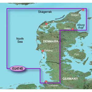
Garmin BlueChart G2 HEU474S Alborg-Eider Data Card
by Garmin
Call for Availabity!
$182.13
$152.99
SKU 41210
Manufacturer Part Number: 010-C0818-10
UPC #: 0
Category: Garmin BlueChart g2 Foreign
Manufacturer Part Number: 010-C0818-10
UPC #: 0
Category: Garmin BlueChart g2 Foreign
See your surroundings more clearly with BlueChart® g2 data. With BlueChart g2, you'll get detailed marine cartography that provides convenient viewing of nautical content. BlueChart g2 allows you to see your vessel's precise, on-chart position in relation to navaids, coastal features, anchorages, obstructions, waterways, restricted areas and more. You will also have access to detailed mapping capabilities that include Safety Shading1, Fishing Charts1, smooth data transition between zoom levels, harmonious transition across chart borders, and reduction of chart discontinuities.
Features
1 in compatible units
Detailed coverage of the Northern and Western coasts of Denmark from Alborg Bugt to Cuxhaven, Germany. Also includes detailed coverage of the cities of Skagen, Thisted, and Esbjerg as well as the Jammerbugten water body.
Features
- Realistic navigation features showing everything from shaded depth contours and coastlines to spot soundings, navaids, port plans, wrecks, obstructions, intertidal zones, restricted areas, IALA symbols and more.
- Smooth display presentation including seamless transitioning between zoom levels and more continuity across chart boundaries.
- Safety Shading1 allows user to enable contour shading for all depth contours shallower than user-defined safe depth.
- Fishing charts1 to help scope out bottom contours and depth soundings with less visual clutter on the display.
- Choice of standard 2-D direct overhead or 3-D "over the bow" map perspective to make chart reading and orientation easier.
- Compatible with HomePort - software that lets you use BlueChart data to conveniently plan and organize routes from your computer before your trip.
1 in compatible units
Detailed coverage of the Northern and Western coasts of Denmark from Alborg Bugt to Cuxhaven, Germany. Also includes detailed coverage of the cities of Skagen, Thisted, and Esbjerg as well as the Jammerbugten water body.
![C-MAP MAX NA-M320 -Passamaquoddy Bay ME-NC: Bathy - C-Card [NA-M320C-CARD]](http://cemarine.com/cdn/shop/files/33236XL_512x512.jpg?v=1731455787)
![Navionics Platinum+ NPUS013R - Canada, West Alaska [010-C1467-40]](http://cemarine.com/cdn/shop/files/102656XL_512x512.jpg?v=1708636877)
![Navionics Platinum+ NPUS012R - Canada, East Great Lakes [010-C1466-40]](http://cemarine.com/cdn/shop/files/102655XL_512x512.jpg?v=1708636871)
![Navionics NAUS013R - Canada, West Alaska - Navionics+ [010-C1467-30]](http://cemarine.com/cdn/shop/files/102654XL_512x512.jpg?v=1708636864)
![Navionics NAUS012R - Canada, East Great Lakes - Navionics+ [010-C1466-30]](http://cemarine.com/cdn/shop/files/102653XL_512x512.jpg?v=1708636857)