
Click or scroll to zoom
Tap or pinch to zoom
C-Map NA-M033 C-Card Format - Atlantic Coast Gulf Caribbean
by C-Map
Call for Availabity!
$299.00
$298.99
SKU 30137
Manufacturer Part Number: NA-M033C-CARD
UPC #: 686074002883
Category: C-Map MAX MegaWide US
Manufacturer Part Number: NA-M033C-CARD
UPC #: 686074002883
Category: C-Map MAX MegaWide US
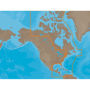
NA-M033 => Atlantic Coast, Gulf of Mexico and Caribbean
Coverage includes most of the eastern coastline of North America. Canadian coverage starts in Arctic Canada and continues east to Hudson Bay, Ungava Bay and Frobisher Bay before continuing south down the Labrador coast to Newfoundland, the Gulf of St. Lawrence and Nova Scotia. The St. Lawrence River is covered down to Montreal. US coverage picks up at Passamaquoddy Bay and heads south down the Atlantic coast, picking up all of Chesapeake Bay, and continuing down to Key West, FL before turning into the Gulf of Mexico. The Gulf of Mexico, from Key West, FL to Brownsville, TX is covered in its entirety. Latin America is covered from the Mexico/US border over around the Yucatan Peninsula along the coasts of Belize, Honduras, Nicaragua, Costa Rica and through the Panama Canal before turning north up the Pacific coastline to Salina Cruz, Mexico. All the islands of the Caribbean are covered, from the Bahamas over to Cuba, east to the Virgin Islands and down to Grenada. The Caribbean coasts of Colombia and Venezuela are also covered, from Golfo de Uraba in Colombia over to the Rio Orinoco delta in Venezuela. Coverage of Bermuda is also included.
Coverage includes most of the eastern coastline of North America. Canadian coverage starts in Arctic Canada and continues east to Hudson Bay, Ungava Bay and Frobisher Bay before continuing south down the Labrador coast to Newfoundland, the Gulf of St. Lawrence and Nova Scotia. The St. Lawrence River is covered down to Montreal. US coverage picks up at Passamaquoddy Bay and heads south down the Atlantic coast, picking up all of Chesapeake Bay, and continuing down to Key West, FL before turning into the Gulf of Mexico. The Gulf of Mexico, from Key West, FL to Brownsville, TX is covered in its entirety. Latin America is covered from the Mexico/US border over around the Yucatan Peninsula along the coasts of Belize, Honduras, Nicaragua, Costa Rica and through the Panama Canal before turning north up the Pacific coastline to Salina Cruz, Mexico. All the islands of the Caribbean are covered, from the Bahamas over to Cuba, east to the Virgin Islands and down to Grenada. The Caribbean coasts of Colombia and Venezuela are also covered, from Golfo de Uraba in Colombia over to the Rio Orinoco delta in Venezuela. Coverage of Bermuda is also included.
![C-MAP MAX NA-M320 -Passamaquoddy Bay ME-NC: Bathy - C-Card [NA-M320C-CARD]](http://cemarine.com/cdn/shop/files/33236XL_512x512.jpg?v=1731455787)
![Navionics Platinum+ NPUS013R - Canada, West Alaska [010-C1467-40]](http://cemarine.com/cdn/shop/files/102656XL_512x512.jpg?v=1708636877)
![Navionics Platinum+ NPUS012R - Canada, East Great Lakes [010-C1466-40]](http://cemarine.com/cdn/shop/files/102655XL_512x512.jpg?v=1708636871)
![Navionics NAUS013R - Canada, West Alaska - Navionics+ [010-C1467-30]](http://cemarine.com/cdn/shop/files/102654XL_512x512.jpg?v=1708636864)
![Navionics NAUS012R - Canada, East Great Lakes - Navionics+ [010-C1466-30]](http://cemarine.com/cdn/shop/files/102653XL_512x512.jpg?v=1708636857)