
Click or scroll to zoom
Tap or pinch to zoom
C-MAP MAX Lakes NA-M020 - Region 4: West - SD-Card
by C-Map
Call for Availabity!
$129.00
$128.99
SKU 30550
Manufacturer Part Number: NA-M020SDCARD
UPC #: 0
Category: C-Map MAX Lakes
Manufacturer Part Number: NA-M020SDCARD
UPC #: 0
Category: C-Map MAX Lakes
Designed for freshwater fishing and hunting, MAX Lakes delivers the highest level of detail and value-added data not found on any other electronic charts on the market. Also, the MAX Lakes database is constantly growing and is updated yearly!
Features:
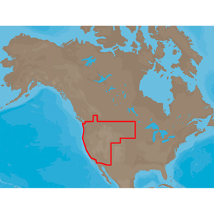
NA-M020 => MAXLakes West
Includes coverage for 700+ lakes in California, Arizona, Utah, Nevada, Wyoming, South Dakota, North Dakota, Montana, Idaho, Oregon and Washington. River coverage includes the Missouri River from Lewis & Clark Reservoir, SD/NE to Lake Sakakawea, ND, Sacramento and San Joaquin Rivers, CA, Columbia River, WA/OR, Snake River, WA/ID and the Willamette River, OR.
Features:
- Shaded Depth Areas
- Points of Interest (POIs) such as campgrounds, shops, gas stations & more
- State Fishing Regulations
- State Hunting Regulations
- Fish Identification Photos
- Water Fowl Identification Photos
- Interstate Highways, Secondary and Lake Roads
- Boat Ramps
- National Parks and Recreation Areas
NA-M020 => MAXLakes West
Includes coverage for 700+ lakes in California, Arizona, Utah, Nevada, Wyoming, South Dakota, North Dakota, Montana, Idaho, Oregon and Washington. River coverage includes the Missouri River from Lewis & Clark Reservoir, SD/NE to Lake Sakakawea, ND, Sacramento and San Joaquin Rivers, CA, Columbia River, WA/OR, Snake River, WA/ID and the Willamette River, OR.
![C-MAP MAX NA-M320 -Passamaquoddy Bay ME-NC: Bathy - C-Card [NA-M320C-CARD]](http://cemarine.com/cdn/shop/files/33236XL_512x512.jpg?v=1731455787)
![Navionics Platinum+ NPUS013R - Canada, West Alaska [010-C1467-40]](http://cemarine.com/cdn/shop/files/102656XL_512x512.jpg?v=1708636877)
![Navionics Platinum+ NPUS012R - Canada, East Great Lakes [010-C1466-40]](http://cemarine.com/cdn/shop/files/102655XL_512x512.jpg?v=1708636871)
![Navionics NAUS013R - Canada, West Alaska - Navionics+ [010-C1467-30]](http://cemarine.com/cdn/shop/files/102654XL_512x512.jpg?v=1708636864)
![Navionics NAUS012R - Canada, East Great Lakes - Navionics+ [010-C1466-30]](http://cemarine.com/cdn/shop/files/102653XL_512x512.jpg?v=1708636857)