
Click or scroll to zoom
Tap or pinch to zoom
C-MAP MAX Lakes NA-M019 - Region 3: South - C-Card
by C-Map
Call for Availabity!
$129.00
$128.99
SKU 30549
Manufacturer Part Number: NA-M019C-CARD
UPC #: 0
Category: C-Map MAX Lakes
Manufacturer Part Number: NA-M019C-CARD
UPC #: 0
Category: C-Map MAX Lakes
Designed for freshwater fishing and hunting, MAX Lakes delivers the highest level of detail and value-added data not found on any other electronic charts on the market. Also, the MAX Lakes database is constantly growing and is updated yearly!
Features:
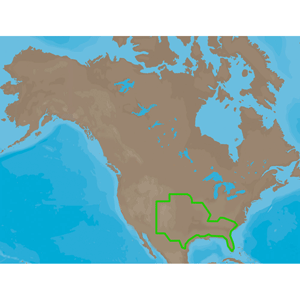
NA-M019 => MAXLakes South
Includes coverage for 800+ lakes in South Carolina, Georgia, Florida, Alabama, Mississippi, Louisiana, Texas, New Mexico, Oklahoma, Kansas, Colorado, Nebraska, Missouri and Arkansas. River coverage includes the Lower Mississippi River from Baton Rouge, LA (MM 210) to Cairo, IL (MM 953), the Upper Mississippi River from Cario, IL (MM 0) to Montrose, IA (MM 375), Arkansas River from Montgomery Point, AR (MM 0) to End of Maintained Channel, OK (MM 444), Red River from Carr Point, LA (MM 0) to Shreveport, LA (MM 237), Black and Ouachita Rivers from Delhoste, LA (MM 0) to Camden, AR (MM 337), Tennessee River from Pickwick Dam, TN (MM 206) to Knoxville, TN (MM 652), Okeechobee Waterway, Savannah River, Tenn-Tom Waterway and the Black Warrior River.
Features:
- Shaded Depth Areas
- Points of Interest (POIs) such as campgrounds, shops, gas stations & more
- State Fishing Regulations
- State Hunting Regulations
- Fish Identification Photos
- Water Fowl Identification Photos
- Interstate Highways, Secondary and Lake Roads
- Boat Ramps
- National Parks and Recreation Areas
NA-M019 => MAXLakes South
Includes coverage for 800+ lakes in South Carolina, Georgia, Florida, Alabama, Mississippi, Louisiana, Texas, New Mexico, Oklahoma, Kansas, Colorado, Nebraska, Missouri and Arkansas. River coverage includes the Lower Mississippi River from Baton Rouge, LA (MM 210) to Cairo, IL (MM 953), the Upper Mississippi River from Cario, IL (MM 0) to Montrose, IA (MM 375), Arkansas River from Montgomery Point, AR (MM 0) to End of Maintained Channel, OK (MM 444), Red River from Carr Point, LA (MM 0) to Shreveport, LA (MM 237), Black and Ouachita Rivers from Delhoste, LA (MM 0) to Camden, AR (MM 337), Tennessee River from Pickwick Dam, TN (MM 206) to Knoxville, TN (MM 652), Okeechobee Waterway, Savannah River, Tenn-Tom Waterway and the Black Warrior River.
![C-MAP MAX NA-M320 -Passamaquoddy Bay ME-NC: Bathy - C-Card [NA-M320C-CARD]](http://cemarine.com/cdn/shop/files/33236XL_512x512.jpg?v=1731455787)
![Navionics Platinum+ NPUS013R - Canada, West Alaska [010-C1467-40]](http://cemarine.com/cdn/shop/files/102656XL_512x512.jpg?v=1708636877)
![Navionics Platinum+ NPUS012R - Canada, East Great Lakes [010-C1466-40]](http://cemarine.com/cdn/shop/files/102655XL_512x512.jpg?v=1708636871)
![Navionics NAUS013R - Canada, West Alaska - Navionics+ [010-C1467-30]](http://cemarine.com/cdn/shop/files/102654XL_512x512.jpg?v=1708636864)
![Navionics NAUS012R - Canada, East Great Lakes - Navionics+ [010-C1466-30]](http://cemarine.com/cdn/shop/files/102653XL_512x512.jpg?v=1708636857)