
Click or scroll to zoom
Tap or pinch to zoom
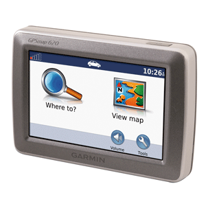
Garmin GPSMAP® 620 All-In-One Marine & Automotive GPS
by Garmin
Call for Availabity!
$699.99
$651.83
SKU 34173
Manufacturer Part Number: 010-00696-00
UPC #: 753759083540
Category: GPS - Chartplotters
Manufacturer Part Number: 010-00696-00
UPC #: 753759083540
Category: GPS - Chartplotters
GPSMAP® 620
Navigate by land and by sea with the Garmin GPSMAP 620. This full-featured marine chartplotter pulls double duty with an automotive mode that's ready to go as soon as you reach the shore when loaded with optional City Navigator NT road maps for North America. And to make sure you always know the way, the GPSMAP 620 comes standard with a high-sensitivity GPS receiver and brilliant, high-resolution touch screen display.
Powerful & Portable
Featuring a marine and an automotive mode, a high-sensitivity GPS receiver, and a rugged case with waterproof (IPX7) design, the GPSMAP 620 is ready for your next outing. The GPSMAP 620 effortlessly shifts gears between marine and automotive modes. When supported by the marine mount, you'll have at-a-glance access to your marine data. And when used with the optional automotive mount and City Navigator NT for North America map data, the automotive mode is automatically activated and the GPSMAP 620 becomes a robust on-the-road navigator.
Designed to Shine
With a brilliant 5.2-inch WVGA touch screen display, and an intuitive interface, you'll have everything you need to navigate with confidence. The GPSMAP 620 comes preloaded with a worldwide satellite basemap for 'view-from-space' imagery of shorelines and other surface features in the area.
By Sea
In marine mode, the GPSMAP 620 provides 3D 'mariner's eye view' above the waterline, 'fish eye view' below the waterline, and Auto Guidance technology that searches chart data to suggest the best passage with optional BlueChart® g2 Vision data. And you'll always get the big picture with a worldwide basemap that comes standard on the GPSMAP 620. The GPSMAP 620 is also NMEA 0183 compliant, so it can be easily added to an existing marine network. And with access to fishing charts, tide and current data, marine services, coastal roads and more via optional BlueChart g2 Vision data, you'll always be in the know while you're on the water.
By Land
In automotive mode, the GPSMAP 620 provides turn-by-turn directions that speak street names (with required City Navigator NT for North America data). And route planning has never been easier. Whether you're searching for boat shops or bait eshops, you'll be able to plan the quickest and most efficient route. You can also create custom points of interests (POIs) and set up proximity alerts to let you know what's in your path as you travel down the road.
![Garmin GC14 Marine Camera [010-02667-00]](http://cemarine.com/cdn/shop/products/89457XL_512x512.jpg?v=1623183122)
![Garmin GC 100 Wireless Camera [010-01865-30]](http://cemarine.com/cdn/shop/products/72576XL_512x512.jpg?v=1576634181)
![Garmin Panoptix PS22-TR LiveV Forward Down Transducer [010-01945-00]](http://cemarine.com/cdn/shop/products/66839XL_512x512.jpg?v=1576632624)
![Garmin Autopilot Check Valve Kit [010-11203-10]](http://cemarine.com/cdn/shop/files/102888XL_512x512.jpg?v=1714598246)
![Garmin Class B Compact v2 Drive Unit [010-12029-01]](http://cemarine.com/cdn/shop/files/103387XL_512x512.jpg?v=1711571379)