
Click or scroll to zoom
Tap or pinch to zoom
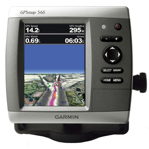
Garmin GPSMAP® 546 GPS Chartplotter
by Garmin
Call for Availabity!
$749.99
$719.99
SKU 36364
Manufacturer Part Number: 010-00774-00
UPC #: 753759096151
Category: GPS - Chartplotters
Manufacturer Part Number: 010-00774-00
UPC #: 753759096151
Category: GPS - Chartplotters
Even in bright sun, it is easy to see the clarity of the GPSMAP 546. These brilliant 5" VGA displays give you a sharp, clear picture, and the fast processor makes for smooth panning and screen redraws as you scroll. Plus, these waterproof units have a high-sensitivity internal GPS receiver, so mariners will alays know their position at sea. They are ready to go with built-in BlueChart g2 marine cartography of the coastal United States - including Alaska, Hawaii, and Explorer Chart data of the Bahamas. Mariners can navigate the waters with ease knowing that these new units include Garmin's proven easy-to-use interface design.
Features and Specifications:
Features and Specifications:
- Bright, crisp 5" diagonal VGA display, 480 x 640 pixels - over 800 nits of brightness
- NMEA 2000 certified for seamless integration with the Garmin marine lineup
- Compatible with GXM 51 for XM Satellite Radio and XM WX Satellite Weather
- Built-in high-sensitivity GPS receiver
- High-speed processor for fast screen redraws and smooth panning
- Streamlined user interface makes it simple to select modes and features
- Single SD memory card slot for BlueChart g2 Vision cards, as well as saving waypoints, routes and tracks to an SD card
- Optional BlueChart g2 Vision cards provide marine chart detail and enhanced navigation features like Auto Guidance, satellite imagery, 3-D Mariner's Eye View and 3-D Fish Eye View
- Backlit keypad for easy operation in low light conditions
- Auto-dimming display
- Unit dimensions: 5.9"H x6.4"W x 2.9"D
![Garmin GC14 Marine Camera [010-02667-00]](http://cemarine.com/cdn/shop/products/89457XL_512x512.jpg?v=1623183122)
![Garmin GC 100 Wireless Camera [010-01865-30]](http://cemarine.com/cdn/shop/products/72576XL_512x512.jpg?v=1576634181)
![Garmin Panoptix PS22-TR LiveV Forward Down Transducer [010-01945-00]](http://cemarine.com/cdn/shop/products/66839XL_512x512.jpg?v=1576632624)
![Garmin Autopilot Check Valve Kit [010-11203-10]](http://cemarine.com/cdn/shop/files/102888XL_512x512.jpg?v=1714598246)
![Garmin Class B Compact v2 Drive Unit [010-12029-01]](http://cemarine.com/cdn/shop/files/103387XL_512x512.jpg?v=1711571379)