
Click or scroll to zoom
Tap or pinch to zoom
C-MAP MAX Lakes NA-M017 - Region 1: North - C-Card
by C-Map
Call for Availabity!
$129.00
$128.99
SKU 30544
Manufacturer Part Number: NA-M017C-CARD
UPC #: 0
Category: C-Map MAX Lakes
Manufacturer Part Number: NA-M017C-CARD
UPC #: 0
Category: C-Map MAX Lakes
Designed for freshwater fishing and hunting, MAX Lakes delivers the highest level of detail and value-added data not found on any other electronic charts on the market. Also, the MAX Lakes database is constantly growing and is updated yearly!
Features:
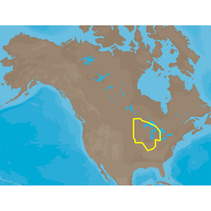
NA-M017 => MAXLakes North
Includes coverage for 9000+ lakes in Minnesota, Wisconsin, Iowa, Illinois, Indiana and Michigan. Coverage also includes Lake of the Woods and Rainy Lake on the Minnesota/Ontario border. Also includes full coverage of Lake St. Clair and western Lake Erie. River coverage includes the Upper Mississippi from Cairo, IL (MM 0) to Brooklyn Park, MN (MM 865), the Ohio River from Cairo, IL (MM 981) to just west of Cincinatti, OH (MM 487), the Illinois River from Grafton, IL (MM 0) to Chicago, IL (MM 319) as well as the Kankakee River in Illinois and the St. Croix River in Minnesota.
Features:
- Shaded Depth Areas
- Points of Interest (POIs) such as campgrounds, shops, gas stations & more
- State Fishing Regulations
- State Hunting Regulations
- Fish Identification Photos
- Water Fowl Identification Photos
- Interstate Highways, Secondary and Lake Roads
- Boat Ramps
- National Parks and Recreation Areas
NA-M017 => MAXLakes North
Includes coverage for 9000+ lakes in Minnesota, Wisconsin, Iowa, Illinois, Indiana and Michigan. Coverage also includes Lake of the Woods and Rainy Lake on the Minnesota/Ontario border. Also includes full coverage of Lake St. Clair and western Lake Erie. River coverage includes the Upper Mississippi from Cairo, IL (MM 0) to Brooklyn Park, MN (MM 865), the Ohio River from Cairo, IL (MM 981) to just west of Cincinatti, OH (MM 487), the Illinois River from Grafton, IL (MM 0) to Chicago, IL (MM 319) as well as the Kankakee River in Illinois and the St. Croix River in Minnesota.
![C-MAP 4D PC-D203 Carolinas, Kiribati, Marshall Marianas [M-PC-D203-MS]](http://cemarine.com/cdn/shop/products/79105XL_512x512.jpg?v=1678216622)
![C-MAP REVEAL X - Gulf of Paria to Cape Horn [M-SA-T-501-R-MS]](http://cemarine.com/cdn/shop/products/93634XL_512x512.jpg?v=1646680588)
![C-MAP REVEAL X - Costa Rica Chile Falklands [M-SA-T-500-R-MS]](http://cemarine.com/cdn/shop/products/93633XL_512x512.jpg?v=1646680581)
![C-MAP REVEAL X - Canada Lake Insight West HD [M-NA-T-218-R-MS]](http://cemarine.com/cdn/shop/products/93632XL_512x512.jpg?v=1646680573)
![C-MAP REVEAL X - Canada Lakes Insight East HD [M-NA-T-217-R-MS]](http://cemarine.com/cdn/shop/products/93631XL_512x512.jpg?v=1646680565)